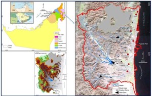
Understanding Soil Erosion in Fujairah City: A Comprehensive Study Using GIS and RUSLE Models
Soil erosion stands as a natural yet pressing environmental challenge that threatens the sustainability of land, ecosystems, and infrastructure across the globe. In Fujairah City, a region renowned for its arid climate and intricate wadi systems, this issue is particularly pertinent. The rising frequency of extreme rainfall events, flash floods, and shifting climatic patterns have significantly accelerated erosion processes, leading to increased sedimentation in local reservoirs and damage to urban infrastructures. This blog explores a comprehensive study that meticulously maps areas prone to erosion within Fujairah, employing advanced methodologies such as Geographic Information Systems (GIS), Remote Sensing, and the Revised Universal Soil Loss Equation (RUSLE) model to assess and address the situation effectively. Understanding the underlying factors contributing to soil erosion in this unique geographical context is essential for developing strategies to manage and mitigate its impacts.Fujairah's geographical position, nestled between the Hajar Mountains and the Gulf of Oman, results in high variability in rainfall patterns, rendering the area susceptible to flash floods. These floods, while crucial for recharging groundwater supplies, have been the catalyst for considerable sedimentation in the city’s dams—specifically Wadi Ham, Safad, and Hayl. The catastrophic floods of July 2022 starkly illustrated this challenge, causing extensive damage to homes, farms, and infrastructure. As sedimentation continues to encroach upon Fujairah’s dams, concerns mount regarding reduced water storage capacity, increased risks of overflow, and compromised flood control measures. Coupled with urban expansion and the exacerbating effects of climate change, the need for a robust soil erosion management strategy has never been more critical. The recent study sheds light on these issues, employing GIS and RUSLE to predict soil erosion based on several key factors, including rainfall erosivity, soil erodibility, slope length and steepness, vegetation cover, and conservation practices. The results revealed that approximately 85% of the area demonstrates low erosion potential, predominantly in vegetated and low-lying regions. However, moderate to high erosion risks persist in about 15% of the area, particularly concentrated around Wadi Ham, Hayl, and Safad, where annual soil loss averages between 25 and 50 tons per hectare, paralleling trends observed in other arid regions of the Middle East and North Africa.
To combat the pressing issue of soil erosion, the study employed a multi-faceted approach using GIS technology and the RUSLE model, identifying critical factors contributing to erosion. Rainfall erosivity, calculated from historical data spanning 2000 to 2023, indicated that the northern parts of Fujairah experience significant erosivity due to intense rainfall events. The analysis also revealed that specific soil types, particularly loamy sand in Fujairah's western regions, exhibit high susceptibility to erosion. Areas with steep slopes, predominantly in the northwest, are at an increased risk, while vegetation cover is crucial in mitigating erosion; regions with minimal cover, such as those upstream and downstream of Wadi Ham, face the greatest threats. Furthermore, the study highlighted the role of conservation practices, showing that urban areas with poor land management practices present the highest erosion risks. To deepen the understanding of the impact of sedimentation on water quality, the study conducted analyses of water and soil samples from the major dams in Fujairah. The results revealed alarming levels of heavy metals, including barium, lead, and chromium, particularly in the waters of Wadi Safad and Wadi Ham, which posed potential environmental risks. This underscores the need for sediment removal strategies to ensure dam functionality and prevent further contamination. Based on these findings, several key recommendations emerged for future management: regular dredging and hydraulic flushing of sediments in the dams, the incorporation of erosion control techniques in urban planning, and enhancing vegetation cover in vulnerable regions. By employing these measures, Fujairah can address the multifaceted challenge of soil erosion, preserving both its urban infrastructure and natural landscapes. Through targeted research and implementation of effective land-use practices, the region can safeguard against the detrimental effects of soil erosion, ensuring a sustainable future for its communities.
Fujairah's unique geography and climatic conditions present distinct challenges in soil erosion management. The integration of advanced models such as RUSLE with GIS and remote sensing technologies provides a robust scientific framework for assessing erosion risks and devising effective mitigation strategies. Addressing sedimentation issues in dams and implementing sustainable land-use practices will be vital in mitigating the adverse impacts of soil erosion in Fujairah. By prioritizing these efforts, the city can enhance its resilience to environmental challenges, fostering a sustainable coexistence between urban development and ecological integrity. This comprehensive approach not only benefits the immediate community but also serves as a model for other regions facing similar environmental concerns. References :Marzen, M., et al. (2019), Wahla, R., et al. (2022), Allafta, H., & Opp, G. (2022)